
Behind the scenes
Real Hong Kong: building 1998 from open data
The coastline, roads and about 24,000 buildings under the Kai Tak approach come from official Hong Kong open data. Here is what is real, and what we changed to make it 1998.
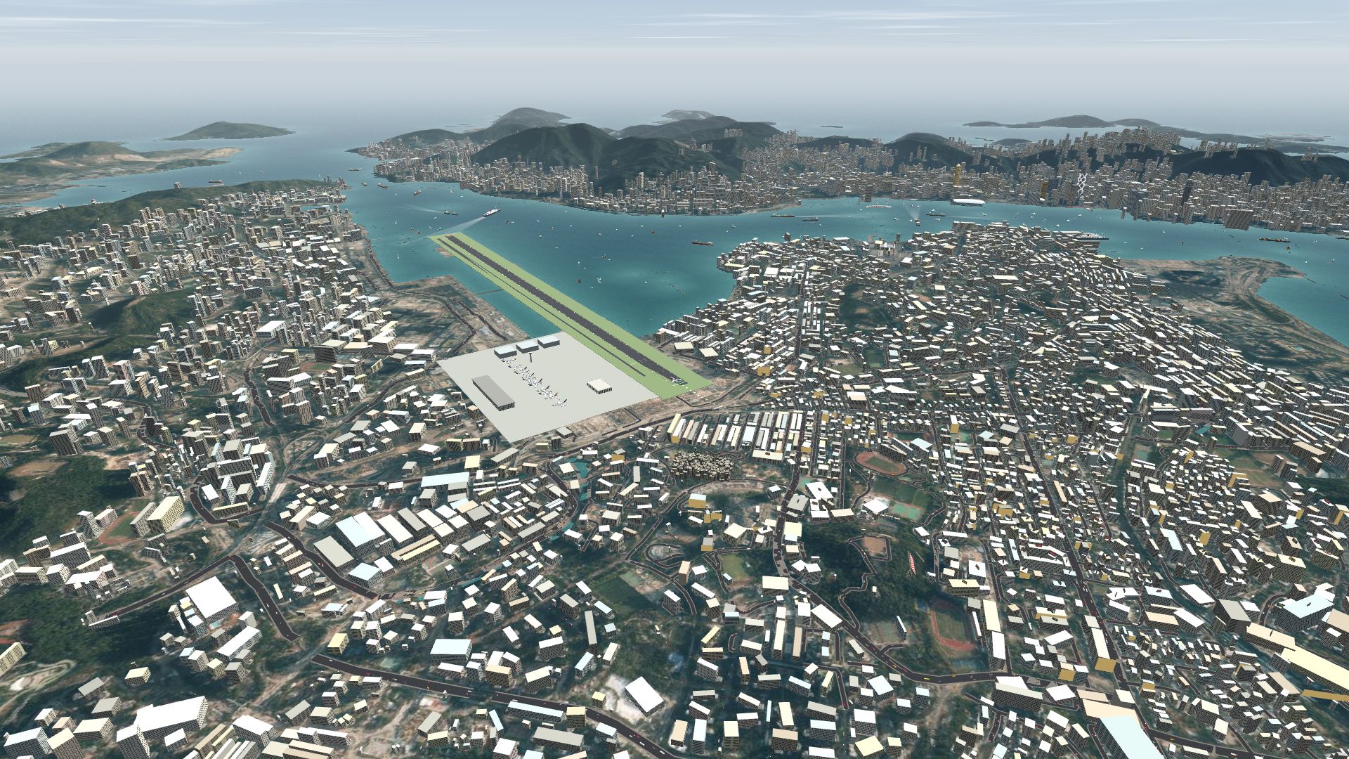
The streets under the Kai Tak approach are not made up. The coastline, the roads and the buildings you fly over come from Hong Kong's own open data, fitted to the real runway, then corrected to match 1998.
What is real
- Imagery, coastline, roads and buildings. The aerial imagery, coastline, main roads and about 24,000 building footprints come from the Hong Kong Lands Department's open data.
- Terrain. Elevation is SRTM, with the building bumps filtered out so a tower block isn't mistaken for a hill.
- The runway. It is fitted to the old Kai Tak strip: threshold 13 at 22.3256°N 114.1926°E, true heading 134.08°.
Making it 1998
Open data shows Hong Kong as it is now, so we had to take things away. The sim removes the buildings on the Kai Tak site and on the West Kowloon reclamation, and the Central Reclamation Phase III waterfront is harbour again.
The skyline is held to the period as well. There is no Two IFC (2003) and no Cheung Kong Center (1999).
The Walled City is an option
Kowloon Walled City was demolished in 1993–94. The sim shows it as it stood before 1994 by default, and you can untick the option to see the 1998 park instead.
Life under the approach
The traffic is built to look like Hong Kong, not just any city.
- On the road. About 6,900 vehicles drive the real main roads and the Kowloon City streets: red Crown Comfort-style taxis with silver roofs, green New Territories taxis, cream minibuses, double-decker buses, lorries and cars.
- On the water. About 134 vessels: Star Ferries on four routes, freighters, container ships, ocean liners, junks, yachts, marine police launches, tugs and ships at anchor, all with proper navigation lights.
- On the signs. The shop signs are drawn from period photos, in Chinese and English, and the neon along Nathan Road is there too. Real corporate logos are left out, and so are real airline names and liveries. The aircraft wear livery-inspired colours instead.
Landmarks
Look for the Bank of China Tower, Central Plaza, The Center, HSBC, Jardine House, Exchange Square, the Convention Centre extension, the TST Clock Tower, the Cultural Centre, Ocean Terminal, the Hung Hom Coliseum, and the Kai Tak terminal and tower. There is also the Garden Hill obstacle beacon in Sham Shui Po.
Build the map yourself
The map data is rebuilt from the source with python3 tools/fetch.py && python3 tools/build.py in the GitHub repo.
Data: © Lands Department, HKSAR Government (CSDI). Elevation: SRTM via AWS Terrain Tiles.
啟德進場航道下面嘅街道並非虛構。你飛越嘅海岸線、道路同建築物,全部來自香港本地嘅開放數據,對準真實跑道,再修正返去 1998 年。
邊啲係真嘅
- 影像、海岸線、道路同建築物。航空影像、海岸線、主要道路同約 24,000 幢建築物輪廓,全部來自香港地政總署嘅開放數據。
- 地形。高度數據係 SRTM,並已濾走建築物造成嘅凸起,免得將一幢大廈誤當成山丘。
- 跑道。佢對準舊啟德跑道:13 號跑道入口位於北緯 22.3256°、東經 114.1926°,真航向 134.08°。
還原 1998 年
開放數據顯示嘅係香港而家嘅模樣,所以我哋要拿走一啲嘢。模擬器移除咗啟德舊址同西九龍填海區上嘅建築物,而中環填海第三期嘅海旁就變返海港。
天際線同樣依足當時嘅年代:冇國際金融中心二期(2003 年),亦冇長江集團中心(1999 年)。
九龍寨城可以揀
九龍寨城喺 1993 至 94 年間拆卸。模擬器預設顯示佢 1994 年前嘅模樣,你亦可以取消剔選,睇 1998 年嘅公園。
進場航道下面嘅生活
交通按香港嘅模樣製作,而唔係隨便一個城市。
- 路上。約 6,900 架車輛行駛喺真實嘅主要道路同九龍城街道:銀頂嘅紅色皇冠 Comfort 款的士、綠色新界的士、乳白色小巴、雙層巴士、貨車同私家車。
- 水上。約 134 艘船隻:四條航線嘅天星小輪、貨輪、貨櫃船、郵輪、中式帆船、遊艇、水警快艇、拖船同下錨嘅船隻,全部都有正確嘅航行燈。
- 招牌上。商店招牌根據當年相片繪製,有中文有英文,彌敦道一帶嘅霓虹燈都有。真實嘅企業標誌被剔除,真實航空公司名稱同塗裝亦冇用,飛機改用受塗裝啟發嘅顏色。
地標
留意中銀大廈、中環廣場、中環中心、滙豐總行、怡和大廈、交易廣場、會議展覽中心新翼、尖沙咀鐘樓、文化中心、海運大廈、紅磡體育館,以及啟德客運大樓同塔台。另外仲有深水埗嘅嘉頓山障礙物燈。
自己建立地圖
喺 GitHub 儲存庫入面,用 python3 tools/fetch.py && python3 tools/build.py 就可以由源頭重建地圖數據。
數據:© 香港特別行政區政府地政總署(CSDI)。高度數據:SRTM,經 AWS Terrain Tiles 提供。
More from the blog
The airlines and aircraft of Kai Tak
A guide to the airlines and aircraft types at Kai Tak in the 1990s: Cathay Pacific, Dragonair, Qantas, BA, Singapore, Thai and JAL, with brief histories.
Read the post →
Other aircraft now bank the right way
Fly Kai Tak fix: other aircraft were drawn banking the wrong way in turns. Arrivals and departures now dip the inside wing, as real jets do.
Read the post →